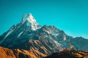
The Himalayas, one of the most majestic mountain ranges in the world, stretch across five countries: Bhutan, India, Nepal, China, and Pakistan. These towering peaks, including the world’s highest, Mount Everest, have fascinated scientists and adventurers alike. The geology of the Himalayas is a compelling narrative of plate tectonics, mountain-building processes, and ongoing geological activity. This article delves into the origins, structure, and geological significance of the Himalayas, exploring the intricate processes that have shaped this monumental range.
1. Formation of the Himalayas
The Himalayas are the result of a colossal collision between the Indian Plate and the Eurasian Plate, a process that began around 50 million years ago during the Eocene epoch. Before this dramatic encounter, the Indian Plate was part of the supercontinent Gondwana, situated much farther south.
1.1 Plate Tectonics and Continental Drift
The theory of plate tectonics provides the framework for understanding the Himalayas’ formation. The Earth’s lithosphere is divided into several large and small tectonic plates that float on the semi-fluid asthenosphere beneath them. Around 200 million years ago, during the Jurassic period, the Indian Plate began to break away from Gondwana and drift northward at an impressive rate of about 15-20 centimeters per year.
The journey of the Indian Plate over such a vast distance is a significant event in geological history. This drift was driven by the movement of molten rock beneath the Earth’s crust, which creates convection currents. These currents, in turn, move the tectonic plates in a process known as continental drift. The Indian Plate traveled from the southern hemisphere to its current position, covering thousands of kilometers over millions of years. This movement was not without consequence, as it led to significant geological changes both on the plate itself and in the regions it interacted with along the way.
1.2 The Collision
As the Indian Plate moved northwards, it eventually collided with the Eurasian Plate. This collision was not a sudden event but a prolonged and complex process that is still ongoing. The immense pressure and friction generated by this collision caused the crust to buckle and fold, giving rise to the Himalayan mountain range. The leading edge of the Indian Plate was thrust under the Eurasian Plate in a process known as subduction, but because both plates are composed of continental crust (which is less dense than oceanic crust), the subduction was limited, leading instead to significant crustal shortening and thickening.
This continental collision is unique because it involves two landmasses. Typically, tectonic activity involves the interaction between oceanic and continental plates, where the denser oceanic plate subducts beneath the lighter continental plate. In the case of the Himalayas, the collision of two continental plates resulted in the crumpling of the Earth’s crust, similar to the effect of a car crash, where the front end of both vehicles crumples upon impact. This crumpling effect led to the creation of the towering peaks we see today.
2. Geological Structure of the Himalayas
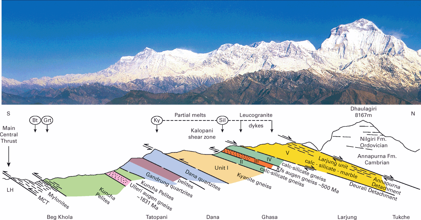
The Himalayas can be divided into several parallel ranges, each with distinct geological features and histories. These include the Outer Himalayas (Siwalik Range), the Lesser Himalayas, the Greater Himalayas, and the Trans-Himalayas.
2.1 Outer Himalayas (Siwalik Range)
The Siwalik Range, also known as the Outer Himalayas, forms the foothills of the Himalayas. These hills are composed of Tertiary sediments, including sandstones, conglomerates, and shales, deposited by rivers flowing from the rising Himalayas. The Siwalik Hills are relatively young, dating back to about 10-2.5 million years ago. This range is characterized by its moderate elevation and its role as a transitional zone between the plains and the high Himalayas.
The sediments that make up the Siwalik Range were eroded from the rising Himalayas and deposited in a foreland basin. This basin formed in front of the advancing mountain range, collecting sediments carried by rivers and streams. Over time, these sediments were compressed and lithified into the sedimentary rocks we see today. The Siwalik Hills also contain rich fossil deposits, providing valuable insights into the flora and fauna that once inhabited the region.
2.2 Lesser Himalayas
North of the Siwalik Range lies the Lesser Himalayas, which rise to elevations of 2,000 to 4,000 meters. This region is composed mainly of sedimentary and low-grade metamorphic rocks, such as slates, phyllites, and quartzites. The rocks of the Lesser Himalayas are older than those of the Siwalik Range, with ages ranging from the Proterozoic to the Cambrian. The Lesser Himalayas are characterized by their steep slopes and rugged terrain, shaped by intense erosion and weathering processes.
The Lesser Himalayas are a zone of significant geological complexity. The region has undergone multiple phases of deformation and metamorphism, resulting in a variety of rock types and structures. The sedimentary rocks in this region were originally deposited in a shallow marine environment and were later subjected to high temperatures and pressures during the Himalayan orogeny. This metamorphism transformed the original sediments into the slates, phyllites, and quartzites that dominate the Lesser Himalayas today.
2.3 Greater Himalayas
The Greater Himalayas, also known as the High Himalayas, form the backbone of the Himalayan range and contain its highest peaks, including Mount Everest and K2. These mountains are primarily composed of highly metamorphosed rocks, such as gneisses, schists, and marbles, which date back to the Precambrian. The Greater Himalayas have undergone multiple phases of metamorphism and deformation, resulting in complex geological structures. This region is also home to some of the world’s largest glaciers, which have significantly shaped the landscape through glacial erosion and deposition.
The Greater Himalayas are characterized by their dramatic topography, with towering peaks, deep valleys, and extensive glacial systems. The high-grade metamorphic rocks in this region were formed deep within the Earth’s crust under extreme conditions of heat and pressure. These rocks were then uplifted and exposed at the surface through the process of tectonic collision. The Greater Himalayas are also a region of active geological research, as scientists study the processes of mountain building, metamorphism, and glaciation that have shaped this rugged landscape.
2.4 Trans-Himalayas
Beyond the Greater Himalayas lies the Trans-Himalayas, a series of ranges that include the Karakoram and Ladakh ranges. The Trans-Himalayas are primarily composed of igneous and metamorphic rocks, including granites, gneisses, and volcanic rocks. These ranges were formed during the collision between the Indian and Eurasian Plates and represent the northernmost extension of the Himalayan orogeny. The Trans-Himalayas are characterized by their arid climate and sparse vegetation, in contrast to the lush forests of the southern Himalayas.
The Trans-Himalayas are a region of stark contrasts, with barren landscapes, high-altitude deserts, and towering peaks. The geological history of this region is complex, involving multiple phases of magmatism, metamorphism, and deformation. The igneous rocks in the Trans-Himalayas were formed from the cooling and solidification of magma, while the metamorphic rocks were formed from the alteration of pre-existing rocks under high temperatures and pressures. The Trans-Himalayas also contain significant mineral deposits, including precious metals and gemstones, which have been mined for centuries.
3. Ongoing Geological Processes
The Himalayas are not static; they continue to evolve due to the ongoing convergence of the Indian and Eurasian Plates. This convergence leads to frequent seismic activity, including earthquakes, and the uplift of the mountain range.
3.1 Seismic Activity
The collision between the Indian and Eurasian Plates generates significant tectonic stress, resulting in frequent earthquakes in the Himalayan region. These earthquakes are caused by the release of accumulated strain along faults within the crust. Notable seismic events include the 2015 Nepal earthquake, which caused widespread destruction and loss of life. Understanding the seismic activity in the Himalayas is crucial for assessing the region’s earthquake hazard and implementing effective mitigation strategies.
The Himalayas are one of the most seismically active regions in the world. The ongoing convergence of the Indian and Eurasian Plates creates significant stress along major fault lines, including the Main Central Thrust and the Main Boundary Thrust. These faults accommodate the movement of the tectonic plates and are the sources of frequent and often devastating earthquakes. Seismologists study these faults and the patterns of seismic activity to better understand the processes driving earthquakes in the region and to develop early warning systems and earthquake-resistant infrastructure.
3.2 Uplift and Erosion
The Himalayas continue to rise at an average rate of about 5 millimeters per year due to the ongoing convergence of the Indian and Eurasian Plates. However, this uplift is counterbalanced by erosion, primarily driven by river systems and glacial activity. Rivers originating in the Himalayas, such as the Ganges, Brahmaputra, and Indus, transport vast amounts of sediment downstream, contributing to the formation of extensive alluvial plains. Glaciers also play a significant role in shaping the Himalayan landscape through processes of glacial erosion and deposition.
The uplift of the Himalayas is a dynamic process influenced by tectonic forces, climate, and erosion. As the mountains rise, they are subjected to intense weathering and erosion, which gradually wears down the peaks and transports sediment to lower elevations. The interplay between uplift and erosion creates a constantly evolving landscape, with new peaks forming as older ones are eroded away. The sediment transported by rivers and glaciers plays a crucial role in shaping the topography of the surrounding regions, contributing to the formation of fertile plains and river deltas.
4. Geological Significance and Research
The Himalayas are of immense geological significance, providing insights into the processes of mountain building, plate tectonics, and Earth’s history. Research in the Himalayas has contributed to our understanding of continental collisions, metamorphism, and the dynamics of the Earth’s crust.
4.1 Plate Tectonics and Mountain Building
The Himalayas serve as a natural laboratory for studying the processes of plate tectonics and mountain building. The collision between the Indian and Eurasian Plates is one of the most well-documented examples of continental collision, providing valuable data on the mechanics of plate interactions. Studies of the Himalayas have revealed the complexities of crustal deformation, including folding, faulting, and metamorphism, which are essential for understanding the formation of other mountain ranges worldwide.
The study of plate tectonics in the Himalayas has led to significant advancements in our understanding of the Earth’s dynamic processes. Geologists use a variety of techniques, including remote sensing, field mapping, and seismic imaging, to investigate the structure and evolution of the Himalayas. These studies have provided insights into the rates of tectonic plate movement, the mechanisms of crustal deformation, and the processes of mountain building. The knowledge gained from studying the Himalayas has also been applied to other regions of the world, helping to unravel the geological history of mountain ranges such as the Alps, Andes, and Rockies.
4.2 Metamorphism and Rock Formation
The high-grade metamorphic rocks of the Greater Himalayas provide important clues about the conditions and processes that occur deep within the Earth’s crust. By studying these rocks, geologists can reconstruct the temperature and pressure conditions that prevailed during their formation. This information helps to unravel the history of tectonic events and the evolution of the Earth’s crust.
Metamorphic rocks in the Himalayas are the result of intense heat and pressure that altered the original sedimentary and igneous rocks. These conditions cause minerals within the rocks to recrystallize, forming new minerals and structures. Geologists study the mineral composition, textures, and structures of metamorphic rocks to understand the processes of metamorphism and the tectonic history of the region. The Greater Himalayas, with their diverse and well-exposed metamorphic rocks, offer a unique opportunity to study these processes in detail.
4.3 Climate and Environmental Research
The Himalayas also play a critical role in regional and global climate systems. The mountains act as a barrier to atmospheric circulation, influencing weather patterns and precipitation distribution. The extensive glaciers and snowfields in the Himalayas are a vital source of freshwater for millions of people living in the surrounding regions. Research on the impacts of climate change on Himalayan glaciers and ecosystems is essential for understanding the potential consequences for water resources, biodiversity, and human populations.
Climate research in the Himalayas focuses on understanding the interactions between the atmosphere, cryosphere, and hydrosphere. Scientists study the patterns of precipitation, temperature, and glacier dynamics to assess the impacts of climate change on the region. The melting of Himalayan glaciers, driven by rising temperatures, has significant implications for water availability and the livelihoods of people who depend on glacial meltwater. Research in the Himalayas also contributes to our understanding of global climate change, as the region’s glaciers are important indicators of broader environmental trends.
The geology of the Himalayas is a testament to the dynamic processes that shape our planet. From the ancient collision of tectonic plates to the ongoing uplift and erosion, the Himalayas continue to evolve and inspire scientific inquiry. Understanding the geology of the Himalayas not only provides insights into Earth’s history and processes but also highlights the importance of preserving this unique and fragile environment for future generations. The Himalayas, with their towering peaks and complex geological history, remain a symbol of the Earth’s ever-changing nature and a source of wonder and discovery.
5. Human Interaction with the Himalayas
Human interaction with the Himalayas has a long history, encompassing exploration, settlement, and the use of natural resources. The mountains have also played a significant role in the cultural and spiritual lives of the people who inhabit the region.
5.1 Exploration and Mountaineering
The Himalayas have long been a destination for explorers and mountaineers drawn by the challenge of climbing the world’s highest peaks. The first successful ascent of Mount Everest by Sir Edmund Hillary and Tenzing Norgay in 1953 is a landmark achievement in the history of mountaineering. Since then, countless expeditions have sought to conquer the many peaks of the Himalayas, each contributing to our understanding of the region’s geology, climate, and ecology.
Mountaineering in the Himalayas requires extensive knowledge of the terrain and weather conditions, as well as physical and mental endurance. The challenges posed by high altitudes, extreme temperatures, and unpredictable weather make climbing in the Himalayas a demanding and often perilous endeavor. The experience of mountaineers provides valuable insights into the physical and environmental conditions of the high-altitude regions, contributing to our understanding of the impacts of climate change on the mountains.
5.2 Settlement and Livelihoods
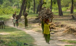
The people living in the Himalayan region have adapted to the challenging environment in a variety of ways. Agriculture, animal husbandry, and trade are the primary means of livelihood for many Himalayan communities. The terraced fields carved into the mountainsides are a testament to the ingenuity and resilience of the people who have lived in this region for centuries.
Traditional agricultural practices in the Himalayas are well adapted to the mountainous terrain and varying climatic conditions. Crops such as rice, maize, millet, and barley are cultivated on terraced fields, while livestock such as yaks, sheep, and goats provide meat, milk, and wool. The people of the Himalayas have also developed intricate systems of irrigation and soil management to sustain their agricultural practices in the challenging environment.
Trade has historically been an important aspect of life in the Himalayas, with ancient trade routes connecting the region to the rest of Asia. The Silk Road, one of the most famous trade routes, passed through the Himalayas, facilitating the exchange of goods, ideas, and cultures. Today, modern transportation infrastructure continues to play a vital role in the economic development of the Himalayan region, connecting remote communities to markets and resources.
5.3 Cultural and Spiritual Significance
The Himalayas hold deep cultural and spiritual significance for the people who live in and around them. The mountains are home to numerous pilgrimage sites, monasteries, and temples that attract devotees from around the world. The spiritual traditions of Buddhism, Hinduism, and indigenous religions are deeply intertwined with the landscape of the Himalayas.
Mountains such as Mount Kailash, considered sacred by Hindus, Buddhists, and followers of the Bon religion, are revered as abodes of the gods and centers of spiritual power. Pilgrimages to these sacred sites involve arduous journeys through challenging terrain, reflecting the devotion and spiritual significance attributed to the mountains. The monasteries and temples of the Himalayas, often perched on high cliffs or nestled in remote valleys, are centers of religious practice, learning, and cultural preservation.
6. Environmental Challenges and Conservation
The unique environment of the Himalayas faces numerous challenges, including climate change, deforestation, and habitat loss. Conservation efforts are essential to preserve the region’s biodiversity and ensure the sustainable use of its natural resources.
6.1 Climate Change
Climate change poses a significant threat to the Himalayan region, affecting its glaciers, weather patterns, and ecosystems. Rising temperatures are causing glaciers to retreat at an alarming rate, leading to reduced water availability for downstream communities and ecosystems. The increased frequency and intensity of extreme weather events, such as floods and landslides, also pose risks to human settlements and infrastructure.
Research on the impacts of climate change in the Himalayas is crucial for developing strategies to mitigate and adapt to these changes. Scientists are studying the patterns of glacier melt, changes in precipitation, and shifts in ecosystems to understand the long-term implications of climate change for the region. Efforts to reduce greenhouse gas emissions and promote sustainable development are essential for protecting the fragile environment of the Himalayas.
6.2 Deforestation and Habitat Loss
Deforestation and habitat loss are significant environmental challenges in the Himalayas. The expansion of agriculture, logging, and infrastructure development has led to the loss of forests and degradation of habitats. This, in turn, threatens the region’s biodiversity, including numerous endemic and endangered species.
Conservation initiatives in the Himalayas focus on protecting forests, restoring degraded habitats, and promoting sustainable land use practices. Community-based conservation programs involve local communities in the management and protection of natural resources, recognizing their traditional knowledge and practices. Protected areas, such as national parks and wildlife reserves, play a crucial role in conserving the region’s biodiversity and ecosystems.
6.3 Sustainable Development
Sustainable development is essential for balancing the needs of human communities and the environment in the Himalayas. Efforts to promote sustainable agriculture, renewable energy, and eco-tourism aim to support economic development while minimizing environmental impacts. Education and awareness programs are also crucial for fostering a culture of conservation and environmental stewardship.
The unique challenges and opportunities of the Himalayan region require innovative approaches to sustainable development. Renewable energy projects, such as hydropower and solar energy, provide alternatives to traditional energy sources and reduce the environmental impact of energy production. Eco-tourism initiatives promote responsible tourism practices that support local economies and protect the natural environment. Sustainable agriculture practices, such as organic farming and agroforestry, enhance food security and resilience to climate change.
The Himalayas are a geological marvel and a symbol of the dynamic processes that shape our planet. From their formation through the collision of tectonic plates to the ongoing uplift and erosion, the Himalayas continue to evolve and inspire scientific inquiry. Understanding the geology of the Himalayas provides insights into Earth’s history, the processes of mountain building, and the impacts of climate change.
Human interaction with the Himalayas, through exploration, settlement, and cultural practices, highlights the deep connections between people and the natural environment. The challenges of climate change, deforestation, and habitat loss underscore the importance of conservation and sustainable development in